Last Updated:
2025-Q2
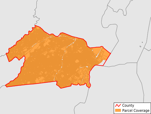
Parcels in County:
149,390
Parcel data available to download as a GDB, GeoPackage, Shapefile, Excel, CSV, or Google Earth KML file.
All purchased data comes with six months of access, including any updates, at no additional cost.
Key attribute coverage for Union County
The percentage of Union County parcels containing the following key attributes:
Owner: 99%
Parcel Number: 100%
Acreage (Calculated): 100%
Site Address: 98.8%
Mailing Address: 98.9%
All available attributes in Union County
Parcel Number
Site Address
Owner
Transfer Date
Sale Price
Building Size
Land Use Code
Land Use Class
Zoning
Acreage (calculated)
Perimeter
Municipality
School District
Zip Code
Flood Zone
Flood Zone Subtype
Census Tract
Census Block Group
Census Block
Total Market Value
Land Market Value
Building Market Value
Mail Address1
Mail Address3
Legal Desc1
Year Built
Total Rooms
Bedrooms
Total Bath
Buildings
Addr Sec Unit Num
Place Gnis Code
Land Cover
Elevation
Owner Occupied
Robust Id
Usps Residential
Alt Id 1
Crop Cover
Acreage Adjacent With Sameowner
Flood Zones
Nearest Transmission Line Dist Ft
Nearest Substation Dist Ft
Derived Geom Properties
Municipalities Respresented in Union County
Hillside Township: 6,243
Union Township: 17,800
Springfield Township: 5,393
Cranford Township: 8,304
Winfield Township: 705
Clark Township: 5,370
Scotch Plains Township: 8,220
Berkeley Heights Township: 4,894
Elizabeth City: 19,697
Fanwood Borough: 2,666
Garwood Borough: 1,549
Kenilworth Borough: 3,057
Linden City: 12,286
Mountainside Borough: 2,832
New Providence Borough: 4,255
Plainfield City: 10,745
Rahway City: 8,470
Roselle Borough: 5,903
Roselle Park Borough: 3,703
Summit City: 7,032
Westfield Town: 10,138
Save money when you buy data in bulk
We offer discounted pricing on county and state downloads.